World
Typhoon Shanshan Causes Severe Weather and Disruptions in Japan
Typhoon Shanshan has brought severe weather conditions and significant disruptions across Japan. Learn about the impact of this powerful storm on local communities, infrastructure, and ongoing recovery efforts.

Typhoon Shanshan Impacts Japan with Severe Weather

Typhoon Shanshan is currently unleashing torrential rains and fierce winds across Japan as it approaches the country’s southwestern region. As of Wednesday afternoon, officials have issued warnings that wind speeds may intensify, posing a risk of severe damage to structures, including the potential for homes to be toppled.
In Aichi Prefecture, located in central Japan, rescue teams are actively searching for three individuals who went missing following a landslide that struck their residence, as reported by the public broadcaster NHK on Wednesday morning. Fortunately, two residents were rescued from the debris.
Japan Airlines announced the cancellation of several flights scheduled for Wednesday, affecting both arrivals and departures at various airports in central Japan, including Osaka Kansai Airport, one of the largest in the nation. All Nippon Airways, Japan’s largest airline, also indicated that operations at Osaka airport would be disrupted due to the storm’s approach.
The Shinkansen, Japan’s renowned high-speed rail network, began canceling some services on Tuesday, with expectations that the number of cancellations would increase on Wednesday and Thursday, according to the operators.
Over a 24-hour period from Tuesday to Wednesday, some cities in central and eastern Japan experienced rainfall amounts reaching up to 10 inches. Additionally, wind gusts were reported at speeds of up to 86 miles per hour, resembling the conditions of a Category 1 hurricane.
The storm has slowed its progression overnight as it neared the Amami Islands, an archipelago located southwest of Japan’s main islands. This sluggish movement is anticipated to significantly enhance rainfall totals in certain regions and extend the duration of damaging winds along the coast, as indicated by the country’s meteorological agency.
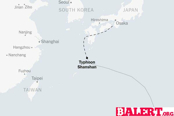
On Wednesday, the typhoon began shifting northward, with forecasts predicting it will approach Kyushu, one of Japan’s major islands, on Thursday. While there is a possibility of landfall in Kyushu, forecasters remain uncertain about the storm’s precise trajectory.
Tracking Typhoon Shanshan
Stay updated on the likely path and expected wind arrival times for Typhoon Shanshan.
The commencement of this year’s Pacific Ocean typhoon season has shown a lower-than-average incidence of tropical storms, a trend attributed in part to the La Niña weather pattern expected to develop later this summer, according to the National Weather Service. La Niña is characterized by cooler sea surface temperatures in the equatorial region, which typically results in increased wind shear—variations in wind speed and direction—across the central Pacific, thereby hindering storm formation, as noted by the Weather Service in May.
Contributions to this reporting were made by Judson Jones.